New Moon in Virgo
Friday, September 22, 2006
7:45am EDT
29º 20'
Annular Solar Eclipse
7:51am EDT
29º 23'
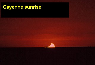
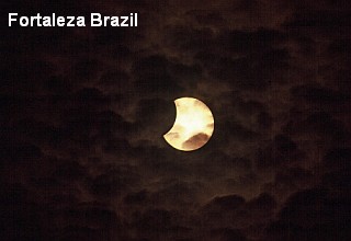
I grabbed a couple of screen shots above from the klipsi eclipse webcam this morning before they went to a four screen live simulation of the partial eclipse. I've searched for an actual live streaming webcast like I watched last spring on March 29th from Turkey of a spectacular total solar eclipse, but to no avail. The link I found at the NASA site for the University of North Dakota webcast did not work. Here you can read more about the New Moon in Virgo.

From the NASA Eclipse Home Page for today's eclipse:
On Friday, 2006 September 22, an annular eclipse of the Sun will be visible from within a narrow corridor which traverses half the Earth. The path of the Moon's antumbral shadow begins in northern South America and crosses the South Atlantic with no further landfall. A partial eclipse will be seen from a much larger region including South America, the eastern Caribbean, western Africa, and Antarctica.
The path of the annular eclipse begins in Guyana at 09:48 UT when the Moon's antumbral shadow meets Earth and forms a 323 kilometre wide corridor. Guyana's capitol city Georgetown lies just a few kilometres outside the path's northern limit. Here, a magnitude 0.920 partial eclipse will be seen at sunrise. On the central line 160 kilometres south, the duration of annularity is 5 minutes 31 seconds.
Rushing east, the antumbra quickly enters Surinam where its capital city Paramaribo lies deep within the antumbral path. Maximum eclipse in Paramaribo occurs at 09:51 UT, the Sun's altitude is 5° and the duration of annularity is 5 minutes 1 seconds. Continuing into French Guiana, the capitol city Cayenne stands just 10 kilometres south of the central line. Maximum eclipse occurs at 09:53 UT as the Sun stands 8° above the eastern horizon during an annular phase lasting 5 minutes 42 seconds.
The southern edge of the antumbra briefly clips the north coast of Brazil before spending the next three and a half hours sweeping across the South Atlantic. Greatest eclipse occurs at 11:40:11 UT. The annular duration is 7 minutes 9 seconds, the path width is 261 kilometres and the Sun is 66° above the featureless horizon of the open ocean. The central track runs south of the African continent and nearly reaches Kerguelen Island before ending at local sunset (13:31 UT). During its 3 hour 40 minute flight across our planet, the Moon's antumbra travels about 13,800 kilometres and covers 0.83% of Earth's surface area.
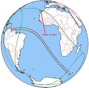
Annular eclipse path image from live.saros.org


No comments:
Post a Comment